
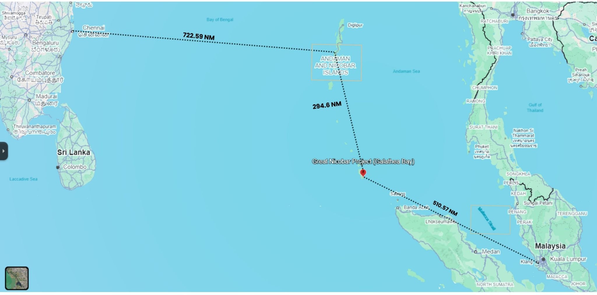
Deep in the vast expanse of the ocean, roughly 810 miles from the Indian mainland, an audacious project is quietly being pursued. One that could redefine the nation’s economic and strategic ambitions.
The Great Nicobar project is not just another infrastructure project. It is India’s attempt to convert geography into economic and geopolitical leverage.

Situated near the Malacca Strait, one of the world’s busiest maritime chokepoints, Great Nicobar sits close to a route central to global trade and energy flows. For decades, it was seen largely as a remote island territory. Today, it is being reimagined as India’s gateway into the Indo-Pacific.
However, Great Nicobar is also a test of India’s strategic state capacity: can India turn geography into maritime leverage while protecting ecology, indigenous rights, disaster resilience, and democratic accountability?
We deep dive into this project in today’s Policy Mandala.
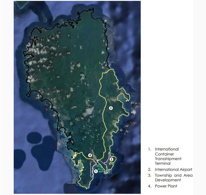
The Great Nicobar Project is a ₹72,000 crore mega development project , one that includes an International Container Transhipment Terminal (ICTT), a Greenfield International Airport, a Gas and Solar-based Power plant, and a new township along with expanded military and maritime access on the southernmost island of the Andaman-Nicobar group.
In-principle approval of the project has been obtained for a sum of ₹ 81,000 crores over thirty years.
Why does this project matter? And why is India building it now?
Two key ideas are driving the thinking and urgency behind the project.
First is the evolving geopolitical scenario.
Rising geopolitical turmoil, while the Hormuz crisis has shown the world the power of strategic maritime zones, China is aggressively building its presence near Malacca. The Great Nicobar project comes as India’s move on the Indo-Pacific chessboard and a rising ambition to be a maritime superpower. We will come to this in detail soon.
Secondly, apart from the geopolitical significance, the project holds key economic value.
To see this, we need to look at transhipment, the idea that maritime cargo has to be offloaded from large vessels and moved to smaller vessels which can dock at usual continental ports. These operations need to be done at specialised ports with high depth and clearance.
Today, nearly 75% of India’s transhipment operations are conducted at foreign ports. India still relies on foreign ports such as Singapore, Colombo, and Port Klang for transhipment before reaching global markets.
Great Nicobar seeks to reduce this dependence by positioning India closer to major international shipping routes.
Developing the Galathea Bay terminal at Great Nicobar is projected to save Indian ports ₹ 2,200 Crore per year on transhipment cargo. This, and more in the form of increased revenue. For comparison, the Singapore Port generates approximately ₹ 80,000 Crore in revenue annually, a major share coming from transhipment.
To appreciate the geopolitical relevance of islands, let’s go back a bit in history.
For centuries, great powers recognized that islands are not peripheral territories but strategic gateways to maritime influence. Indian kingdoms were not strangers to maritime strategy and the Cholas projected naval power deep into Southeast Asia and influenced trade routes across the Bay of Bengal and the Malacca region.
According to Chola inscriptions the Nicobar Islands (Nakkavaram) held particular significance in Chola maritime geography. These islands acquired strategic significance as outposts for naval expeditions against the Srivijayan (Sumatran) territories.
But modern India gradually became continental in its strategic thinking. Securing borders and solving territorial disputes dominated policymaking for decades, while the seas remained secondary in our priorities.
That mindset is now beginning to change, and perhaps nowhere is this transition more visible than in Great Nicobar Island. India’s geopolitical policy chambers have finally begun to focus on maritime strategy and the critical role of islands in the same.
The Indo-Pacific is rapidly becoming the centre of global strategic competition. The term appears eight times in the US National Security Policy, more than any other similar region.
The establishment of the Andaman and Nicobar Command in 2001 already reflected India’s growing recognition of the strategic importance of the island chain in the eastern Indian Ocean. Yet further developments eluded for long.
Great Nicobar lies close not only to the Malacca Strait but also to the wider Indo-Pacific Sea routes linked to the Sunda and Lombok Straits, both increasingly important amid rising geopolitical competition and concerns over maritime disruption.
This is where Beijing enters the room.
Over the last two decades, China has invested aggressively in maritime infrastructure to strengthen the string of pearls, its landmark maritime move, across the Indo-Pacific, from Gwadar in Pakistan to Hambantota in Sri Lanka and ports across the wider Indian Ocean region, a willingness to reshape geography itself.
In the South China Sea, it has transformed reefs and submerged features into militarised artificial islands, with airstrips, ports, radar systems, and military facilities. By some estimates, China has created more than 3,000 acres of new land across the Spratly Islands alone.
With these moves, China has fundamentally challenged India’s assertion of the Indian Ocean as our strategic backyard. China wants to close in on Malacca and Great Nicobar is perhaps India’s best bet against the dragon’s dance.
The real question is whether India can develop the project with enough speed, coordination, ecological caution, and democratic legitimacy.
While the easy part has been accomplished, the long road awaits with the project facing financial, ecological and anthropological challenges.
Because Great Nicobar is not a blank spot on a strategic map. It is a living island, with forests, coral systems, endangered species, indigenous communities, and memories of disaster.
The island forms part of the UNESCO-recognised Great Nicobar Biosphere Reserve and contains dense tropical forests, coral ecosystems, and habitats for endangered species including the leatherback turtle and Nicobar megapode.
Large-scale infrastructure expansion has triggered fears over deforestation, biodiversity loss, and irreversible ecological disruption.
The island is also home to the Shompen tribe, classified as a Particularly Vulnerable Tribal Group, whose relationship with the island’s forests and ecological systems has evolved over generations in relative isolation.
There is another uncomfortable reality often ignored in strategic discussions that is, Great Nicobar is also geologically unstable.
The region was severely affected during the 2004 Indian Ocean tsunami, with tectonic shifts altering parts of the island landscape itself. The Nicobar belt remains seismically active and raises difficult questions about the long-term sustainability of large-scale urban and maritime infrastructure in one of the Indian Ocean’s most disaster-prone zones.
Yet dismissing the project entirely would also oversimplify reality.
Maritime infrastructure, logistics corridors, ports, and islands are increasingly shaping geopolitical influence. Every major power is repositioning itself accordingly. Especially in the case of China’s attempted dominance, India cannot remain absent from this transition and it makes Great Nicobar such a defining project.
However, unlike authoritarian systems of the likes of China that can impose strategic projects with limited public scrutiny, India faces a more complex democratic challenge.
Can India build strategic infrastructure without weakening ecological safeguards? Can maritime ambition coexist with indigenous protections and environmental caution? Can India pursue geopolitical influence without replicating the extractive logic often criticised in other major powers?
At the centre of the answer to these questions lies a single term, state capacity.
State capacity is not just about money. It is about continuity, coordination, monitoring, diplomatic partnerships, and the ability to build under geopolitical pressure without cutting ecological corners.
To illustrate further, take the case of transhipment.
The Great Nicobar port will not become a success merely because it exists. It will become successful when global shipping lines trust it, when neighbouring countries route cargo through it, when customs processes are fast, when turnaround time is predictable, and when the port is integrated into regional trade networks. All this requires state intent and capacity.
Great Nicobar’s transhipment will therefore need not only construction capacity but commercial diplomacy: partnerships with shipping lines, port operators, Southeast Asian economies, and Indian exporters who must see it as a reliable alternative to Singapore, Colombo, or Port Klang.
Similar challenges will lay across the project execution and the long road ahead it paves. India’s state machinery has to run the project across governments, ministries, investors, local communities, environmental regulators, defence priorities, and global shipping networks without losing momentum or legitimacy.
Thus state capacity and execution may ultimately determine whether Great Nicobar becomes a successful maritime gateway or a cautionary tale of strategic overreach.
Where do we see the project if India is able to pull this off amidst hurdles?
If the project succeeds, India could achieve transhipment independence and generate valuable revenue for future projects. Local economy will get a boost as projections estimate the port could generate ₹30,000 crore annually by 2040 and create up to 50,000 jobs.
In the future, control over data routes and undersea communication networks such as SEA-ME-WE could become as significant as control over sea lanes themselves, placing the island and the project at the centre of India’s emerging maritime and technological ambitions in the Indo-Pacific.
The development will function as a forward operating base for the Indian military, boosting the nation’s rapid response capabilities and building a strong first line of defense in the eastern Indian Ocean.
If Great Nicobar eventually integrates port infrastructure, naval access, surveillance systems, and submarine cable connectivity, it could become a rare strategic node where trade, security, and data routes meet.
And eventually Great Nicobar would be the first of many.
India’s future maritime ambitions in Great Nicobar Island may also encourage the development of advanced resilient infrastructure designed for one of the world’s most dynamic oceanic regions.
Future projects could integrate earthquake-resistant engineering, tsunami-resilient port systems, climate-adaptive infrastructure, and secure submarine cable architecture into a new model of island development.
In this vision, Great Nicobar would not only represent India’s expanding maritime reach, but also its capacity to build technologically sophisticated and future-ready infrastructure at the crossroads of the Indo-Pacific.
Hence, somewhere along the coastlines of Great Nicobar Island, India may be deciding what kind of maritime power it wants to become.
References:
R. Champakalakshmi. (1996). Trade, ideology and urbanization: South India 300 BC to AD 1300. Oxford University Press.
Holistic Development of Great Nicobar Island at Andaman & Nicobar Islands
Kaplan, R. D. The South China Sea is the future of conflict. Foreign Policy, August 15, 2011.
Asia Maritime Transparency Initiative. Center for Strategic and International Studies (CSIS), June 16, 2015.
U.S. Embassy in Georgia. China’s construction companies sow chaos worldwide. U.S. Embassy in Georgia. September 10, 2020
Authored & Edited By: Avdhesh Pathak and Samridh Joshi
Well written - comprehensive.
Came across another researched article on this topic
- https://beyondthefyp.com/infopack/great-nicobar-project-between-environmental-concerns-and-strategic-cost-5265